
Scottish Borders Region
Sighty Crag - G/SB-005
Next SB Summit
Previous SB Summit
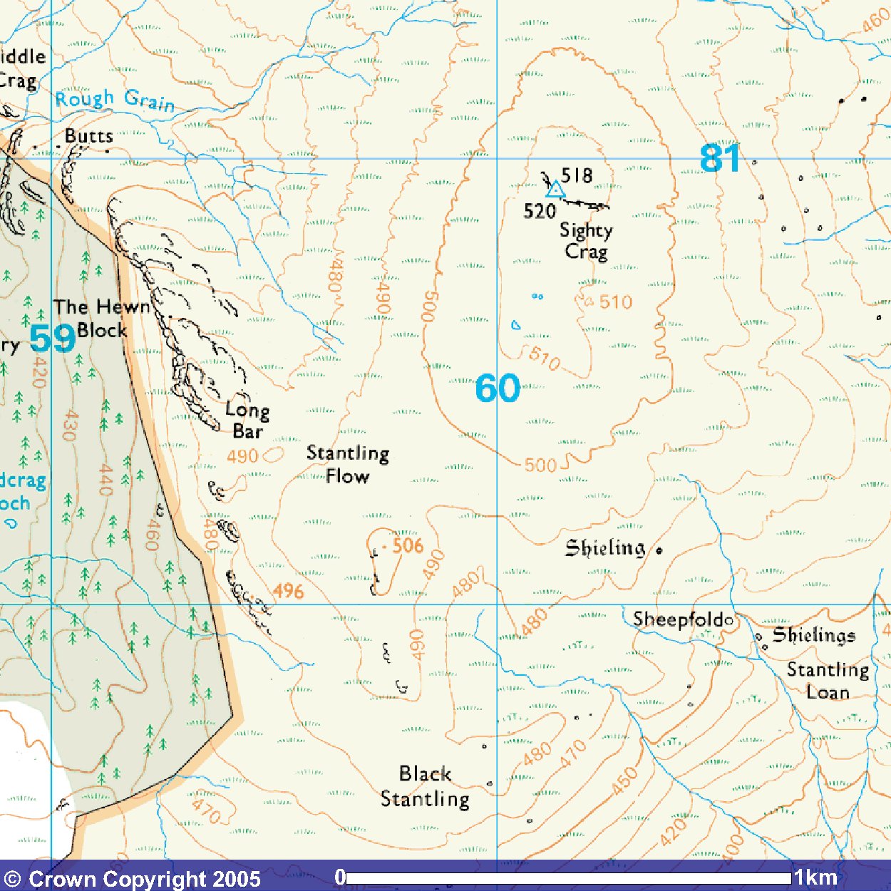
| Grid Reference | NY 60140 80910 |
| Latitude/Longitude | 55°7'15.4"N, 2°37'35.5"W |
| Maidenhead Square | IO85QC |
| Height | 518 M / 1699 ft |
| Points | 2 |
| Bonus | 3 points between 1/12 and 15/3 |
Sighty Crag is the southern-most summit in the SB region and is the only one that is not in the county of Northumberland being in Cumbria. The best starting point for walking to this summit is from near the Flatt. Getting there by road requires some careful navigation along a series of minor local roads. The inaccessibility, roughness and feeling of remoteness of Sighty Crag caused Marilyn bagger, David Robinson to write:
We guys who hills in Blighty bag
Might shy away from Sighty Crag.
It surely is a mighty drag
Enough to make the sprightly flag
When faced with forest, mire and hag
Shrouded in a whity clag.
But conquer and you'll rightly brag
'I found the top of Sighty Crag!'
Descending is a further fag
And goes to show we're slightly mad.
It is perhaps because of its remoteness that this summit remained inactivated for quite so long until activated by John G4YSS operating with the Scarborough SEG callsign GX0OOO/P on 1st December 2004. VHF activation with at least a half wave antenna is possible with clear paths into Tyneside, Teeside, North & West Cumbria and South West Scotland. Summit to summit should be possible with other SB summits with the possible exception on Housedon Hill and with SS summits that are not hidden by the range of hills from Peel Fell slightly east of north round The Cheviot to the north east. As it is the southernmost of all SB summits, geographically close to the Lake District and just across the Irthing valley from the Northern Pennines, it should generally be good for summit-summit contacts as there is a clear path into the regularly activated LD and NP summits. NW and SP summits may also be possible.
|
|
|
 |
|
|
© Crown
Copyright 2005 Image produced from Ordnance Survey's Get-a-map service. Image reproduced with kind permission of Ordnance Survey and Ordnance Survey of Northern Ireland. |
|
&
Explorer OL 43 Hadrian's Wall
Note that "open country" is indicated by the light yellow shading
Next SB Summit
Previous SB Summit
Getting There,
From the south west take the M6 north to junction 43 where after coming up the exit slip road you should take the third exit off the roundabout into the A69 east signposted for Hexham and Newcastle. Continue on the A69 toward Brampton, but on reaching the Brampton bypass do not take the A69 which takes a right turn off the roundabout but continue straight on into Brampton. Arriving in Brampton, bear right into Carlisle Road and before it changes to become Main Street take a sharp left turn into the A6071 signposted for Longtown. Continue on the A6071 for 1.7 miles and shortly after crossing the river Irthing turn right into a local road toward Walton. Just after you enter Walton the road bears left and continues NNE out of the village. Just over 2 miles after Walton you will meet the B6318 where you take the left branch to the north west continuing on the B6318 for just over 6½ miles till you come to a point where the B6318 turns left while a local minor road that you take, continues straight on. After 0.7 mile, you will arrive at T junction where you should take the right branch followed by the next left after just under half a mile. At the next junction after another 0.8 mile bear right where you briefly join national cycle route 10 for just under a mile. At the next junction where the cycle route turns right, you bear left and after 0.4 mile take the right branch of a Y junction which after about 160 yards you will come to the edge of the forest and the forestry road where there should be space to park.
From the south east depending on your starting point and road preferences you have a choice of:
- taking the M1/A1(M) north, branching left off the A1(M) at
junction 58 on to the A68 just north of Scotch Corner, then after a
further 15 miles, at the roundabout near Crook take the first exit left
onto the A689 and continue on that to Brampton. When the A689 merges
with the A69 at the Brampton bypass take a right hand dog leg to continue
straight ahead into Brampton and from there follow the directions above
from the south west.
- taking the M1/A1(M) north, branching left off the A1(M) at
junction 58 on to the A68 just north of Scotch Corner, then continuing
on the A68 until it merges onto the A69. Once on the A69 continue on
it ignoring the A68 branch off, past Hexham, through Haydon Bridge and
round the Haltwhistle bypass till you reach a very short stretch of
dual carriageway where the B6318 is signposted to the right to Greenhead.
Follow the directions as from the south west above where it joins the
B6318.
- taking the M1/A1(M) north all the way to Newcastle/Gateshead and shortly after crossing the Tyne on the western bypass taking the slip road up to turn left into the A69, and then follow the directions in option 2 immediately above.
From the north east take the A1 south to
Newcastle and from there take the A69 west following thereafter option 2
above.
From the north west take the M74/A74(M)/M6
south to M6 junction 43 then follow directions from the south west
Suggested Approach,
approx. walk in 3.66 miles 5.9km
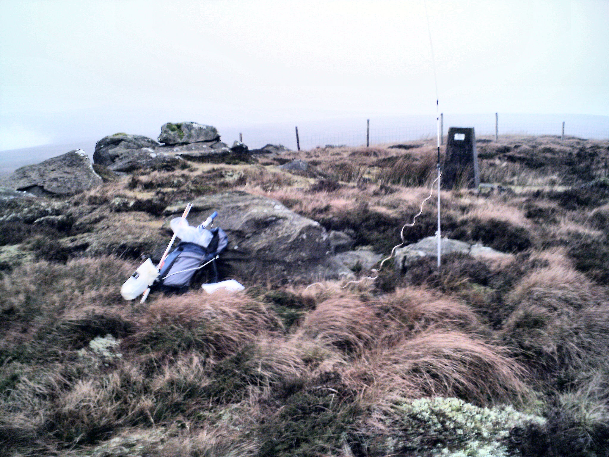 |
| The trig point on the top of Sighty Crag bears a plate indicating that it is an OS Passive Station used as a GPS reference point. |
GPS Route Download,
Download Garmin Mapsource GDB
format »
Download Memory Map format »
Post Summit Retreat,
For refreshments after activation, .the Lime Kiln Inn at Shopford, Bewcastle
is just a short distance to the south of the Flatt along national cycle
route 10. Food is available at lunch time (except Wednesday) and in
the evening. Following the return route south on the B6318 the Crossings
pub is situated on a crossroad just south of Lyneholmeford with lunchtime
food apparently only on a Sunday, and evening meals on Friday-Sunday. If
you turn right (west) at that same crossroads the Drove Inn, Roweltown,
about a mile along that minor road has reputation for good evening meals.
Last updated 9th June 2005