
Scottish Borders Region
Shillhope Law - G/SB-006
Next SB Summit
Previous SB Summit
| Grid Reference | NT 87309 09683 |
| Latitude/Longitude | 55°22'51.3"N, 2°12'06.6"W |
| Maidenhead Square | IO85VJ |
| Height | 501 M / 1644 ft |
| Points | 2 |
| Bonus | 3 points between 1/12 and 15/3 |
Shillhope Law lies well into Upper Coquetdale, a very picturesque area of Northumberland well away from civilisation, but very popular with walkers, cyclists and others who enjoy getting out into the country away from it all.
|
|
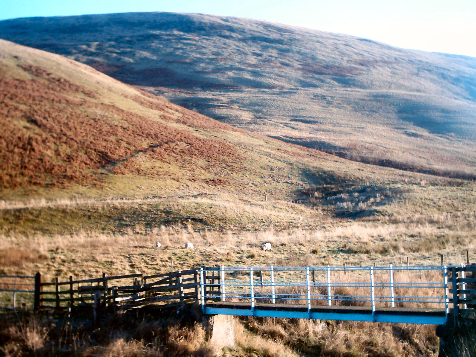
Looking across the bridge over the Coquet at Weder Leap towards Shillhope Law |
Most of the area around Shillhope Law, indeed much of upper Coquetdale became "open country" following the implementation of CRoW in May 2005. However there are quite a number of small areas that are not included in the "open country" and they ought to be fairly obvious as they tend to be enclosed fields. There are such areas both at Barrowburn and at Shillmoor, but these do not affect the suggested routes.
VHF activation with at least a half wave antenna, is practicable with good signals passing down the Coquet valley into the Northumberland and Tyneside areas. Summit to summit is possible with other SB summits, LD, NP some SS and possibly SP.
|
|
|
 |
|
|
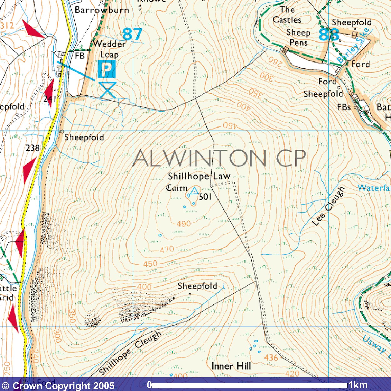
© Crown
Copyright 2005 Image produced from Ordnance Survey's Get-a-map service. Image reproduced with kind permission of Ordnance Survey and Ordnance Survey of Northern Ireland. |
|
Note that "open country" is indicated by the light yellow shading
Next SB Summit
Previous SB Summit
Getting There,
From the south there are two options depending on your starting point:
- Take the A697 north off the A1 just north of Morpeth, passing through
the Northumberland village of Longhorsley. About 2½ miles north of Longhorsley
after quite a long downhill run, in the dip before a long steady rise
toward the village of Longframlington, take the B6344 left for Rothbury.
Continue on the B6344 to the village of Rothbury where just as you come
into Rothbury the road number changes to the B6341. Pass straight through
Rothbury and the next village of Thropton and about 1.8 miles
after Thropton where the B6341 turns left, a minor road, which you take,
signposted for Alwinton, Harbottle, and Sharperton continues almost
straight ahead. Continue on this road through Sharperton, Thropton,
and into the village of Alwinton ignoring all other side roads. Arriving
in Alwinton the road turns left, passes the Rose and Thistle on the
left, and the National Park Car Park on the right, a convenient place
for a toilet stop. From Alwinton onward this road is for some of the
time a dead end at Chew Green after another 12 miles. However in
recent years, provided the red flag at Chew Green is not flying
(regardless of other red flags) the road up to middle golden pot and
then down to the A68 via Cottonshope is open to traffic . Long
before Chew Green, for Shillhope
Law there are two suggested starting points, the first you will come
to at Shillmoor, just over 3 miles from Alwinton and the second
just before Barrowburn from a car park on the left about 5.6 miles beyond
Alwinton.
- From the A1 Newcastle Western Bypass take the slip road signposted for the A696 to Jedburgh and Ponteland, and proceed along this dual carriageway past Newcastle Airport, where the dual carriage way ends, through Ponteland and the village of Belsay, past Kirkwhelpington and the Knowesgate Motel, till at the hamlet of Raylees 14 miles beyond Belsay, you take a right turn off the A696 into a minor road signposted for Elsdon. If you wish to avoid this minor road which is quite narrow, you can continue on the A696 for a further 1.9 miles, where you make a very sharp right turn into the B6341 signposted for Elsdon and Rothbury. From Elsdon follow the directions from the north west immediately below.
From the north west take the A68 south passing through Jedburgh, past the Catcleugh reservoir and through the Redesdale Forest. Just over 2 miles after passing through Rochester, in a very short section of dual carriageway, the A68 branches off to the right and the road straight ahead, on which you continue, becomes the A696. Two miles south of this, you will come into the village of Otterburn and about a mile further on, where the A696 turns to the right, continue straight ahead onto the B6341 for Elsdon and Rothbury. At Elsdon continue to follow the B634 which bears left up the hill at the far end of the village. Continue on the B6341 through the Grasslees Valley and watch out for a road on the left after about 5 miles from Elsdon and shortly after a National Park car Park, that you should take, signposted for Holystone. After just over three miles on this road and after passing through Holystone you will come to a T junction where you turn left. Your are now on the road toward Harbottle and Alwinton as detailed above from the south, so follow those directions above.
The Otterburn Ranges website suggests that the Cottonshope road will be open most of the year, although several times I have been there it has been closed. Shortly after passing the Catcleugh reservoir and Byrness, there is a signposted road on your left at Low Byrness for the military ranges. The website indicates that if there is no red flag at this point then access to the coquet valley via the Cottonshope Road up to Middle Golden Pot and then left down Dere Street to Chew Green is possible. From there you simply follow the road down the valley past Makendon, Fullhope, Blindburn, Carlcroft, Carshope and will arrive at Wedder Leap car park just after Barrowburn. So it is worth checking whether there is a red flag flying on the post at Low Byrness. Of course a week either side of Christmas and from mid April to mid May the ranges are normally open, so the route should be open.
From the north east take the A1 south to
Alnwick and just after the road opens to a dual carriageway, take the slip
road up the ramp and turn right across the bridge toward Alnwick.
You have to follow signs toward the centre of Alnwick but keep an eye out
for signs for the B6341 to Rothbury and take that road. Just over
6½ miles from the outskirts of Alnwick there is a crossroads of the B6341
with the A697. Continue straight across this which will take you into Rothbury
and from here follow the first option directions as from the south above.
Suggested Approach,
For this summit there are two routes popular with walkers and some walking routes traverse Shillhope Law going up one
|
|
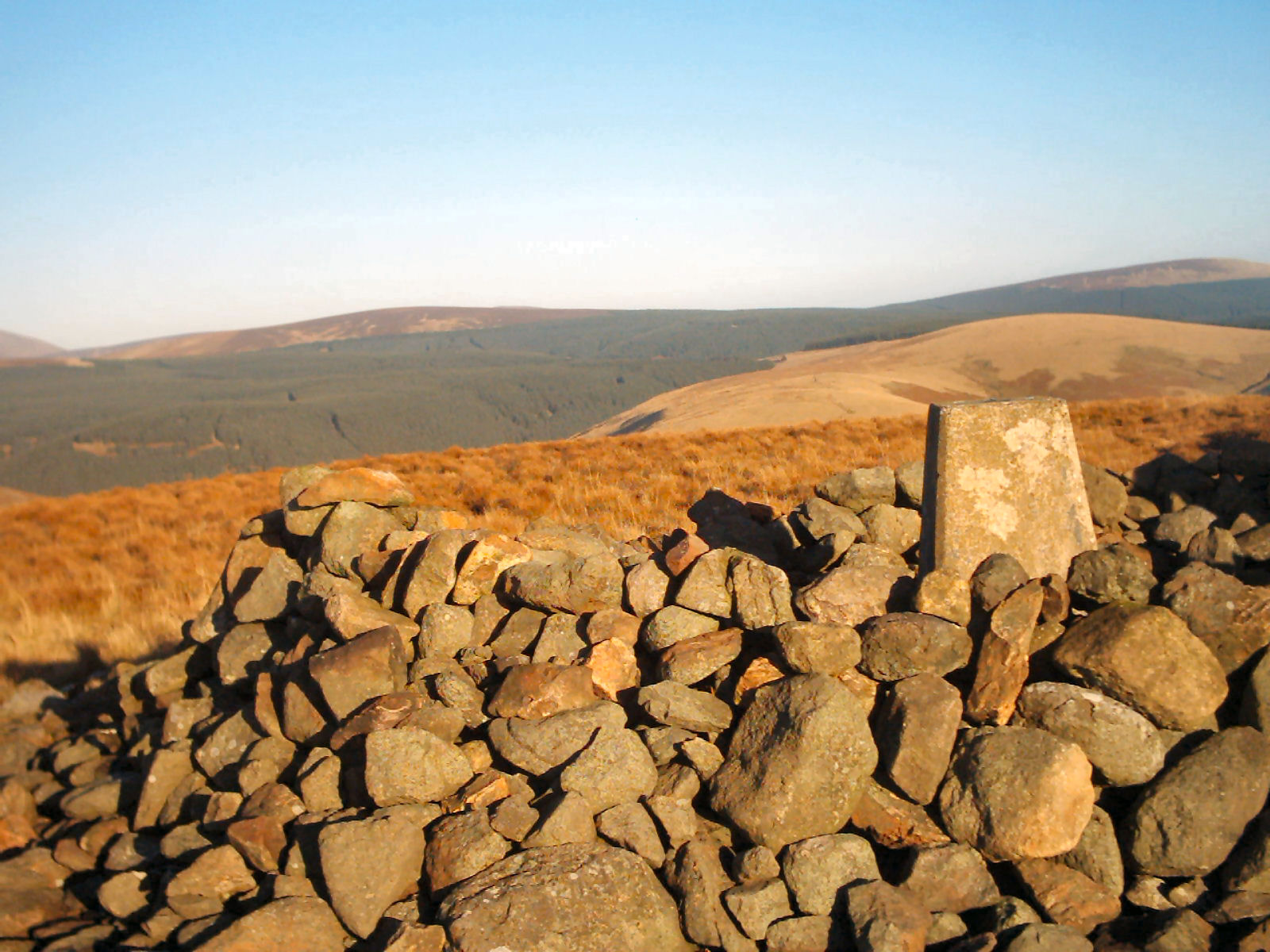
The trig point surrounded by a cairn on the summit of Shillhope Law |
Shillmoor Approach: approx walk in 1.65 miles 2.65km
There is space for parking at the side of the road beside the cluster of houses at Shillmoor NT 88545 07760. From there take the old road that passes between the houses and then take the left fork when it branches shortly after. Thereafter simply follow the track up to Inner Hill, across the ridge, then up to the summit of Shillhope Law. In fact there are now several quad bike tracks heading up the last part of the hill and most will lead to the summit. The trig point here is surrounded by a hollow cairn so careful positioning can offer some shelter from the wind.
Barrowburn Approach:
approx walk in 0.85 miles 1.37km
There is a car park at NT 8663 1033, Wedder Leap, just before Barrowburn
in the grounds of what was originally a school. However this parking
facility is under threat as the MOD may wish to use the site for other
purposes, so it may disappear. From the car park, cross the road and
then the river over the bridge at NT 8667 1042. Head straight across the
edge of the trees and after going through the gate turn right (south).
Cross the shoulder of the hill, aiming for the obvious valley with a
fence on your right. You will see a fence in front of you which is
topped with barbed wire but at NT 8702 1017 there is a small wooden step
(not exactly a stile) which will allow you to cross safely. Continue up
the valley following the line of the fence till you meet a quad bike
track and a gate through the fence where you turn right to follow the
track up to the summit.
GPS Route Download,
Shillmoor Approach:
Download Garmin Mapsource
GDB format »
Download Memory Map format »
Barrowburn Approach:
Download Garmin Mapsource
GDB format »
Download Memory Map format »
Post Summit Retreat,
For refreshments after activation, the Rose and Thistle in Alwinton
serves food at lunchtime except on Mondays when it is closed at lunchtime
apart from Bank Holidays and is very used to walkers as probably most of
its daytime customers are outdoor enthusiasts. A short distance further
down the valley at Harbottle, the Star Inn is a favourite evening haunt
of many of the local shepherds. Considerably further down the valley at
Thropton, the Cross Keys on the left as you climb out of the village on
the other/eastern side has a reputation for its varied fish menu, and the
landlady has been known to conjure up fish and chips late into the afternoon
for starving walkers. Of course if your return trip takes you back
through Rothbury, there is always the Newcastle Hotel that is recommended
on the SB-007 Tosson Hill and SB-008 Long Crag pages.
Last updated 12th June 2009